Bay of Kotor, or Boka Kotorska (also Boka Kotorska Bay) (see on Montenegro map), is one of the most striking and memorable natural beauties not only of Montenegro, but of the entire Adriatic coast, rightfully called the most beautiful and southernmost fjord in Europe. The majestic mountains, narrowing, plunge into the turquoise waters of the Adriatic, forming a complex bay, whimsically scattered along the shores of fishing villages, ancient fortified cities and modern cottage villages, open to tourists all year round.
The territory of the Bay of Kotor has a rich and vibrant history: over the past two millennia, these lands have attracted the Romans, Greeks, Slavs, Turks, French and Italians, who appreciated the favorable geographical location and favorable climatic conditions of the Bay of Kotor.
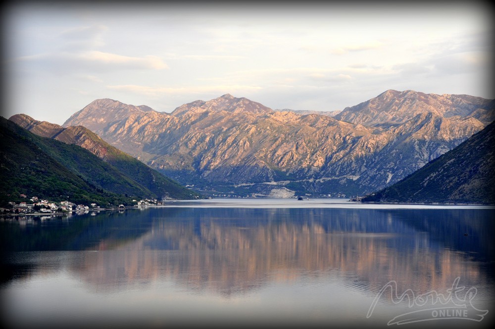
Inspection-detour of the Bay of Kotor, start from the city Herceg Novi - the extreme point of the bay in the northwest and the nearest city to the border with Croatia. IN Herceg Novi visit Old city, which is a medieval fortress, which once submitted to the Ottoman Empire. Here, listen to the sound of the surf against the fortress walls - because further on the waves will become less and less and they will completely disappear at the deepest point - Kotor (see photo). map of the Bay of Kotor).
Continue your journey towards the villages Djenovici and Baosicifacing the green peninsula Lustica. If it's hot outside, don't miss the chance to swim in one of these villages and continue on your way inland. Driving through Kamenari, pay attention to the ferry plying to the opposite shore (village Lepetane). If you have to return to Herceg Novi, then you can take a short cut on the ferry, the ferry leaves about every five minutes as it fills up, the fare by car is 4.5 euros, if you walk it is free, but definitely worth the views.

Passing Kamenari, we rush to the village Morin, which is located in Morinj Bay and has one of the longest beaches on the Bay of Kotor, covered with small pebbles. From Morin you will see the pearl of the Bay of Kotor - Mt. Perast with two islands - St. George and Mary on the Reef. After Morin your let it run through Risan, in the past one of the main cities on the Bay of Kotor. Wander the narrow streets of Risan leading up to the mountains. Passing by the village Drazhn Wrt, do not be deceived by its apparent inconspicuousness - a good beach is hidden under the highway, called Bayova Kula.

The next point of the route is the famous Perast. Perast inscribed on the UNESCO World Heritage List, along with Sveti Stefan is one of the most expensive and prestigious places for recreation and residence in Montenegro. Walk around this small town, a real open-air museum, hire a boatman and raft to the island or take a kayak and raft to the island again. Have a bite to eat on the waterfront of Perast, admiring the islands and the unhurried life of the locals. Imagine that about 3 centuries ago, the coast of Perast served as a haven for almost 300 ships, and the Russian Tsar Peter I sent future Russian sailors to Perast for training.
If you are overwhelmed with impressions, it makes sense to continue your acquaintance with the Bay of Kotor the next day. In any case, we continue to old Kotorbypassing the villages Orahovac, Lyutu and kindness. Here our trip reaches its climax - we wander through the strange streets of the old city, buy souvenirs, observe the numerous cats that Kotor sheltered, try to conquer the fortress of St. Ivan, we stop by the old serpentine cattaro stairs and take breathtaking panoramic photos of the Bay of Kotor and old Kotor.

Then we walk along the first line of Dobrota, or continue our way through the villages Muo, Prcanj and Stoliv.
We complete the review of the Bay of Kotor in Tivat (where we go to Budva) or return to Herceg Novi.


Other photos of the Bay of Kotor look at our page Facebook! Let's be friends!


